

(FWA 2025/11/7)Taiwan’s Central Weather Administration (CWA) stated today (7th) that weather will be relatively stable this weekend (Nov 8-9) due to a Pacific high-pressure system. However, the public must closely monitor Typhoon Fung-wong (No. 26). According to the latest typhoon potential path map released at 14:00, Fung-wong will make a significant northward turn after next Tuesday (11th) and is expected to be closest to Taiwan next Wednesday (12th).
Briefly Partly Cloudy to Sunny Weekend; North & East to See Changes Sunday Night
The CWA noted that from Friday to Sunday daytime, most of Taiwan will see partly cloudy to sunny skies with minimal cloud cover. This pattern will change on Sunday evening as northeasterly winds strengthen, increasing moisture and the chance of rain in northern and eastern regions.
Fung-wong Continues to Intensify, Forecast to Become Strong Typhoon by Sunday
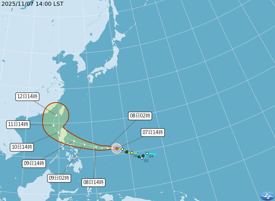
CWA data shows that Mild Typhoon Fung-wong (as of 14:00, Nov 7) was centered at 11.7°N, 136.7°E, about 2,000 km southeast of Taiwan, moving west at 20 km/h.
The forecast indicates the typhoon will continue to intensify, expecting to become a “Strong Typhoon” (max. wind speed 51 m/s) around Sunday (9th) and pass north of the Philippines’ Luzon Island on Monday (10th).
Path Map Shows Clear Northward Turn; Closest Approach Likely Next Wednesday
According to the latest potential path map, after entering the South China Sea on Tuesday (11th), Typhoon Fung-wong will make a distinct “turn to the north-northeast,” approaching the Bashi Channel and the seas near southern Taiwan.
The CWA forecasts that by 14:00 next Wednesday (12th), the typhoon’s center will move to 22.3°N, 119.1°E, very close to the coast of southern Taiwan. The CWA reminds the public that typhoon path forecasts still have uncertainty, and everyone should pay close attention to the latest typhoon updates.


