

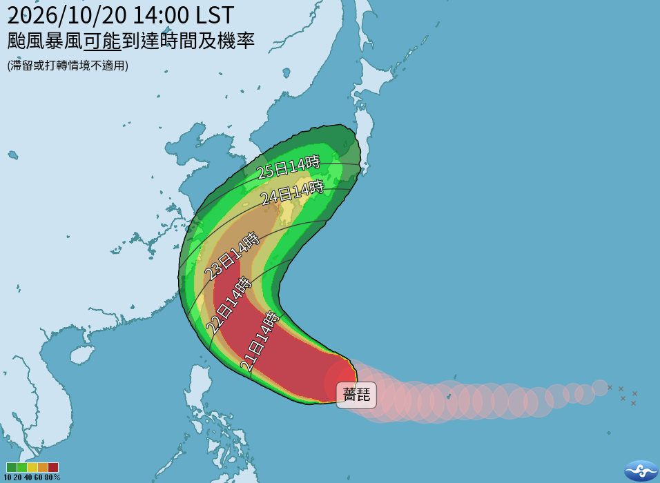

(FWA 2026/10/20)Will there be a typhoon day off? Severe Typhoon Champi continues to approach, with its most severe impact on Taiwan expected between Thursday and Friday. According to the Central Weather Administration’s storm invasion probability forecast, the chances for Taipei, New Taipei, Keelung, Taoyuan, Yilan, and Hualien all exceed 60%.
According to the latest observation data from the Central Weather Administration at 2:00 PM on the 20th, the center of Severe Typhoon Champi is currently located at 16.4 degrees North latitude and 134.3 degrees East longitude, moving west-northwest at a speed of 24 kilometers per hour. The typhoon has a massive and intense structure, with a central pressure of 910 hPa, a maximum wind speed near the center of 55 meters per second, and maximum instantaneous wind gusts of 68 meters per second. Regarding the storm radius, the average radius of Beaufort scale 7 winds is 250 kilometers, and the average radius of Beaufort scale 10 winds is 120 kilometers.
The forecast track indicates that Typhoon Champi will continue moving west-northwest before turning northwest. Its intensity will reach its peak within the next 12 to 18 hours, with the maximum wind speed near the center expected to reach 60 meters per second, and the radius of Beaufort scale 7 winds expanding to between 280 and 300 kilometers.
The most severe impact on Taiwan is expected to occur between Thursday and Friday (the 22nd and 23rd). By then, the center of the typhoon will reach the eastern waters of Taiwan and gradually turn northward, posing a direct threat to the land in the northern and eastern regions.
According to the “120-hour probability of typhoon storm invasion,” both Keelung City and Yilan County stand at 61%; Taipei City is at 56%, New Taipei City at 54%, Hualien County at 54%, and Taoyuan City at 51%.
According to Article 4 of the “Work and Class Suspension Guidelines for Natural Disasters,” if meteorological forecasts indicate that a typhoon’s storm radius is likely to pass through an area within four hours, and its average wind force reaches Beaufort scale 7 or above, or gusts reach scale 10 or above; or if forecasts or actual observations show rainfall reaching the reference standards for work and class suspension set by the responsible reporting agencies, with disasters having occurred or likely to occur, the respective responsible agencies may announce a typhoon day off (suspension of work and classes).
Magkakaroon ba ng “Typhoon Day Off” (Walang pasok)? Patuloy na Lumalapit ang Malakas na Bagyong Champi
(FWA 2026/10/20)Magkakaroon ba ng “Typhoon Day Off”? Patuloy na lumalapit ang Malakas na Bagyong “Champi” (CHAMPI), at inaasahang ang pinakamatinding epekto nito sa Taiwan ay mula Huwebes hanggang Biyernes. Ayon sa taya ng Central Weather Administration (CWA) tungkol sa posibilidad ng pagtama ng bagyo, ang tyansa para sa Taipei, New Taipei, Keelung, Taoyuan, Yilan, at Hualien ay higit sa 60%.
Ayon sa pinakabagong datos ng obserbasyon ng CWA bandang 2:00 PM ng ika-20, ang sentro ng Malakas na Bagyong Champi ay kasalukuyang nasa 16.4 degrees hilagang latitud at 134.3 degrees silangang longitud, na kumikilos pa-kanluran-hilagang-kanluran sa bilis na 24 kilometro bawat oras. Ang bagyo ay may napakalaki at malakas na istruktura, na may central pressure na 910 hPa, maximum wind speed malapit sa sentro na 55 metro bawat segundo, at maximum instantaneous wind gusts na 68 metro bawat segundo. Tungkol sa storm radius, ang average radius ng lakas ng hangin na level 7 ay 250 kilometro, at ang average radius para sa level 10 na hangin ay 120 kilometro.
Ipinapakita ng forecast track na ang Bagyong Champi ay patuloy na kikilos pa-kanluran-hilagang-kanluran bago lumiko pa-hilagang-kanluran. Ang lakas nito ay aabot sa pinakamataas na antas sa loob ng susunod na 12 hanggang 18 oras, kung saan ang maximum wind speed malapit sa sentro ay inaasahang aabot sa 60 metro bawat segundo, at ang storm radius ng level 7 na hangin ay lalawak mula 280 hanggang 300 kilometro.
Ang pinakamatinding epekto sa Taiwan ay inaasahang magaganap sa pagitan ng Huwebes at Biyernes (ika-22 at 23). Pagsapit ng panahong ito, ang sentro ng bagyo ay aabot sa silangang karagatan ng Taiwan at unti-unting liliko pahilaga, na magdudulot ng direktang banta sa mga kalupaan sa hilaga at silangang bahagi ng bansa.
Ayon sa “120-hour probability of typhoon storm invasion,” ang Keelung City at Yilan County ay parehong nasa 61%; ang Taipei City ay 56%, New Taipei City ay 54%, Hualien County ay 54%, at Taoyuan City ay 51%.
Ayon sa Artikulo 4 ng “Work and Class Suspension Guidelines for Natural Disasters,” kung ipinapakita sa weather forecast na ang storm radius ng bagyo ay posibleng dumaan sa isang lugar sa loob ng apat na oras, at ang average na lakas ng hangin nito ay umabot sa level 7 pataas o ang pagbugso ng hangin ay umabot sa level 10 pataas; o kung batay sa forecast o aktwal na obserbasyon ay umabot ang dami ng ulan sa pamantayan para sa pagsuspinde ng trabaho at klase na itinakda ng mga responsableng ahensya, at nagdulot na ng sakuna o may banta ng sakuna, maaaring mag-anunsyo ang mga kaukulang ahensya ng pagpapawalang-pasok sa trabaho at klase (Typhoon Day Off).